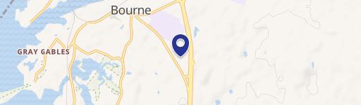
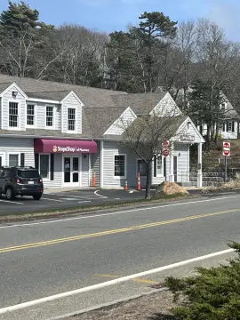
2 Katie Marie Dr Bourne, MA 02532-8342
Property profile & analytics
2 Katie Marie Dr, Bourne, MA 02532-8342
- Showrooms
- 5,600 SF
- 0.92 lot acres
Property ID
US38-0796647
The Realmo ID is a unique identifier assigned to every property, incorporating country codes and precise geo-coordinates for 300x300-foot land blocks. It enables standardized data collection and seamless integration of disparate sources such as ownership, tax, title data and physical specifications. By aggregating current and historical records, the Realmo ID powers advanced analytics and delivers deep, verifiable insights for real estate professionals.
Location Intelligence
Current Use by Public Records
- Stone Supply LLC / Building Supply
- Advance Marble & Granite / General Contractor / Construction Company
Property Details for 2 Katie Marie Dr
- Year built
- 2011
- Construction
- STEEL FRAME
- Lot size
- 0.92 lot acres
- Zone code
- B-4
- Property type
- Showrooms
- APN
- BOUR M:35.0 P:141
- APU
- BOURM350P141
Sales History
| Date | Price | Buyer | Seller | Deed Type | Mortgage |
|---|---|---|---|---|---|
| Feb 20, 2019 | — | Twin Hldgs LLC | — | Deed · related | $189k · Main Street Bk (ma) |
| Mar 3, 2011 | $361,461 | Twin Holdings LLC | 2 Katie Marie Dr LLC | Grant Deed · related | $300k · Marlborough Savings Bank |
| Mar 20, 2008 | — | 2 Katie Marie Drive LLC | — | Deed Of Trust · related | $55k · Marlborough Savings Bank |
| Mar 9, 2007 | — | 2 Katie Marie Dr LLC | — | Deed Of Trust · related | $375k · Marlborough Savings Bank |
| — | — | Twin Hldgs LLC | — | Deed Of Trust · related | $189k · Main Street Bk (ma) |
Value Estimations
based on Realmo’s proprietary methodology
-
CAP approach
- CAP Return
- Estimation
- 6%
- $1,300,000
- 6.5%
- $1,200,000
- 7%
- $1,115,000
-
Comparable approach
- Method
- Estimation
- Statistic Estimate
- $934,000
- AI Estimate
- $734,000
Market price range: $466k - $1.26MMarket price range: $315k - $1.19M -
Alternative Use
- Use
- Estimation
- COMMERCIAL (GENERAL)
- $870,000 Current use
- RESTAURANT
- $1,390,000 Change: +60% Conversion: Difficult
- RETAIL STORES
- $1,265,000 Change: +46% Conversion: Easy
- OFFICE BUILDING
- $1,260,000 Change: +45% Conversion: Easy
- AUTO REPAIR, GARAGE
- $960,000 Change: +10% Conversion: Difficult
- INDUSTRIAL (GENERAL)
- $860,000 Change: -1% Conversion: Moderate
Get a detailed, property-specific estimation — fast and free
Location Insight
- Map
- Local Demand
- City
- Bourne
- County
- Barnstable
- State
- Massachusetts
- Longitude
- -70.584
- Latitude
- 41.7099
- CBSA code
- 12700
- CBSA name
- BARNSTABLE TOWN, MA METROPOLITAN STATISTICAL AREA
Property Tax & Assessments
Tax date
Tax Amount
Assessed Land Value
Assessed Improvement Value
Total Assessed Value
Applied Tax Rate
Land Market Value
Improvement Market Value
Total Market Value
2024
$6,868
$588,900
$267,500
$856,400
-
$0.00
$0.00
$0.00