18125 10th Mile Rd Roseville, MI 48066-3803
Property profile & analytics
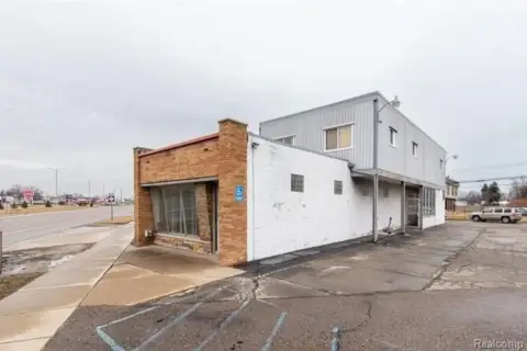
18125 10th Mile Rd, Roseville, MI 48066-3803
- Drive through restaurants
- 28,300 SF
- 11.49 lot acres
Property ID
US43-1367810
The Realmo ID is a unique identifier assigned to every property, incorporating country codes and precise geo-coordinates for 300x300-foot land blocks. It enables standardized data collection and seamless integration of disparate sources such as ownership, tax, title data and physical specifications. By aggregating current and historical records, the Realmo ID powers advanced analytics and delivers deep, verifiable insights for real estate professionals.
Location Intelligence
Current Use by Public Records
- Drive through restaurants
Property Details for 18125 10th Mile Rd
- Year built
- 2019
- Lot size
- 11.49 lot acres
- Zone code
- I-1
- Property type
- Drive through restaurants
- APN
- 08-14-20-453-004
- APU
- 81420453004
Sales History
| Date | Price | Buyer | Seller | Deed Type | Mortgage |
|---|---|---|---|---|---|
| Jun 25, 2019 | $1,000,000 | Aksa Holding LLC | Becker Properties LLC | Grant Deed | — |
| Aug 24, 2016 | — | Aksa Holding LLC | Becker Properties LLC | Quit Claim Deed | — |
Value Estimations
based on Realmo’s proprietary methodology
-
Comparable approach
- Method
- Estimation
- Statistic Estimate
- $6,129,000
- AI Estimate
- $6,129,000
Market price range: $2.46M - $6.67MMarket price range: $2.46M - $6.67M -
Alternative Use
- Use
- Estimation
- RESTAURANT
- $4,010,000 Current use
Get a detailed, property-specific estimation — fast and free
Location Insight
- Map
- Local Demand
- City
- Roseville
- County
- Macomb
- State
- Michigan
- Longitude
- -82.9347
- Latitude
- 42.4819
- CBSA code
- 19820
- CBSA name
- DETROIT-WARREN-LIVONIA, MI METROPOLITAN STATISTICAL AREA
Property Tax & Assessments
Tax date
Tax Amount
Assessed Land Value
Assessed Improvement Value
Total Assessed Value
Applied Tax Rate
Land Market Value
Improvement Market Value
Total Market Value
2022
$200,161
$0.00
$0.00
$2,976,800
-
$0.00
$0.00
$5,953,600