Property profile & analytics
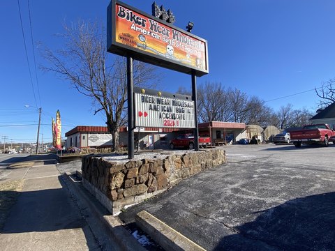
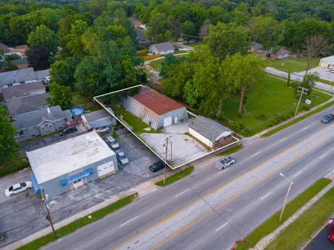
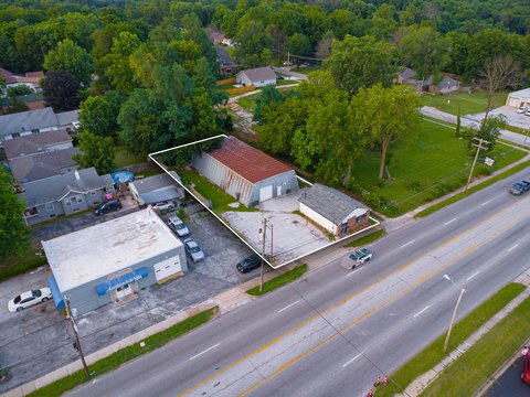
1219 Kearney St Springfield, MO 65803-4147
- Retail space
- 1,288 SF
- 0.33 lot acres
OFF-MARKET
Value Estimations
Cap Rate Potential
Location Intelligence
Property ID
US48-0785273
The Realmo ID is a unique identifier assigned to every property, incorporating country codes and precise geo-coordinates for 300x300-foot land blocks. It enables standardized data collection and seamless integration of disparate sources such as ownership, tax, title data and physical specifications. By aggregating current and historical records, the Realmo ID powers advanced analytics and delivers deep, verifiable insights for real estate professionals.
Current Use by Public Records
- Retail space
Property Details for 1219 Kearney St
- Year built
- 1950
- Lot size
- 0.33 lot acres
- Property size
- 1,288 SF
- Zone code
- INC
- Property type
- Retail space
- APN
- 88-12-06-302-033
- APU
- 881206302033
Description
This exceptional 1.55-acre commercial land parcel presents a unique investment opportunity in Springfield, Missouri. Strategically located on West Kearney Street, this property benefits from high visibility and traffic flow due to its proximity to historic Route 66. The land is comprised of two parcels totaling 1.55 acres; the primary parcel is situated on West Kearney Street, while the secondary 1.28-acre parcel is located on North Fort Avenue. This provides flexibility for development and potential expansion. The property is zoned for Highway Commercial use, offering a wide range of development possibilities for various businesses and building types. The surrounding area is experiencing significant growth, with new construction projects underway, further enhancing the property's value and potential for future appreciation. The asking price for this prime commercial land is $175,000. The property's location in Greene County, Missouri, with a zip code of 65803, provides easy access to Springfield's amenities and infrastructure. This is an excellent opportunity for investors and developers seeking a well-located, versatile commercial land parcel in a thriving market. The coordinates are 37.241224 latitude and -93.305897 longitude.
Value Estimations
based on Realmo’s proprietary methodology
-
AI approach
-
CAP approach
-
Comparable approach
-
Alternative Use
Get a detailed, property-specific valuation — fast and free
Location Insight
- Map
- Local Demand
- City
- Springfield
- County
- Greene
- State
- Missouri
- Longitude
- -93.2739
- Latitude
- 37.2408
- CBSA code
- 44180
- CBSA name
- SPRINGFIELD, MO METROPOLITAN STATISTICAL AREA
Property Tax & Assessments
Tax date
Tax Amount
Assessed Land Value
Assessed Improvement Value
Total Assessed Value
Applied Tax Rate
Land Market Value
Improvement Market Value
Total Market Value
2023
$4,288
$25,090
$42,180
$67,270
-
$78,400
$131,800
$210,200