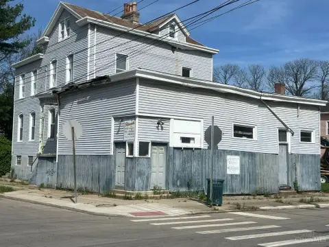
1119 William Howard Taft Rd Cincinnati, OH 45206-2030
Property profile & analytics
1119 William Howard Taft Rd, Cincinnati, OH 45206-2030
- Apartment buildings
- 184,840 SF
- 2.23 lot acres
Property ID
US66-1359548
The Realmo ID is a unique identifier assigned to every property, incorporating country codes and precise geo-coordinates for 300x300-foot land blocks. It enables standardized data collection and seamless integration of disparate sources such as ownership, tax, title data and physical specifications. By aggregating current and historical records, the Realmo ID powers advanced analytics and delivers deep, verifiable insights for real estate professionals.
Location Intelligence
Current Use by Public Records
- Apartment buildings
Property Details for 1119 William Howard Taft Rd
- Year built
- 1925
- Lot size
- 2.23 lot acres
- Property type
- Apartment buildings
- APN
- 066-0001-0010-00
- APU
- 660001001000
Sales History
| Date | Price | Buyer | Seller | Deed Type | Mortgage |
|---|---|---|---|---|---|
| Oct 30, 2018 | $3,200,000 | Alms Hill Preservation LP | Pe Alms Hill Realty LLC | Trustees Deed · related | $23.8M · Keybank USA |
| Nov 24, 2014 | — | Pe Alms Hill Realty LLC | Pure Alms LLC | Quit Claim Deed · related | — |
| Jun 30, 2014 | — | Pure Alms LLC | Pe Alms Hill Realty LLC | Quit Claim Deed | — |
| May 3, 2013 | $4,582,104 | Pe Aims Hills Realty LLC | Downtown Property Management I | Grant Deed | $3.8M · Cp Cincinnati LLC |
| Apr 13, 2007 | $2,300,000 | Downtown Property Mgmt INC | Alms Hill II | Grant Deed | $1.9M · Fifth Third Bank |
Value Estimations
based on Realmo’s proprietary methodology
-
Comparable approach
- Method
- Estimation
- AI Estimate
- $1,785,000
Market price range: $1.79M - $4.33M
Get a detailed, property-specific estimation — fast and free
Location Insight
- Map
- Local Demand
- City
- Cincinnati
- County
- Hamilton
- State
- Ohio
- Longitude
- -84.4859
- Latitude
- 39.1269
- CBSA code
- 17140
- CBSA name
- CINCINNATI-MIDDLETOWN, OH-KY-IN METROPOLITAN STATISTICAL AREA
Property Tax & Assessments
Tax date
Tax Amount
Assessed Land Value
Assessed Improvement Value
Total Assessed Value
Applied Tax Rate
Land Market Value
Improvement Market Value
Total Market Value
2023
$823
$9,342
$0.00
$9,342
-
$26,690
$0.00
$26,690