
New search
Property profile & analytics
OFF-MARKET
Estimated value
$580,000
Gas stations
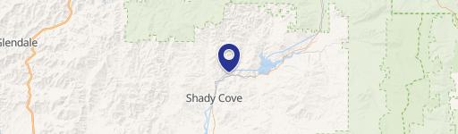
10668 Hwy 62, Eagle Point, OR 97524-4616
Individually Owned
17-yr Hold
Free & Clear
Property ID
US71-1726764
Property profile
Verified
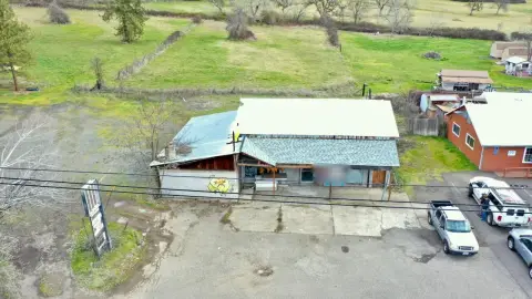
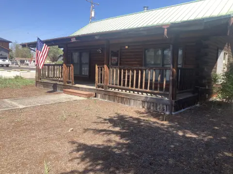
Property type
Gas stations
Use group
SERVICE STATION (FULL SERVICE)
Year built
1998
Total area
2,932 SF
Lot
1.16 ac (50,530 SF)
Zoning code
C-4
APN
1-0210897
UPID
US71-1726764
Cap rate & NOI
Priority signal for investors
Implied cap rate, NOI & suggested price
Cap rate vs submarket · NOI estimate · 3 price anchors
Implied cap rate, NOI & suggested price
Cap vs submarket · NOI estimate · 3 price anchors
Value estimations
Realmo proprietary · 4 methods
AI Approach
AI
by Request
CAP Approach
CAP
by Request
Comparable Approach
Comparable
by Request
Blend (final)
Blend
$580k
Owner & transaction history
Luke Ozcelik · 17 yrs held
Luke Ozcelik
since 2009
7 recorded transactions
Zoning & alternative use
C-4 · Eagle Point, OR
Permitted uses
Permitted uses
Allowed · conditional · prohibited
Cap rate
Implied · in-place · derived from last sale + estimated NOI
Implied Cap rate
#1
Implied · in-place · NOI ÷ last sale
In-place · derived from last sale + estimated NOI
Cap rate, NOI & submarket benchmark
Implied cap rate vs Eagle Point submarket · NOI estimate · Typical band, median & reading
Implied cap rate, NOI & submarket benchmark
Cap vs Eagle Point submarket · NOI estimate · typical band, median & reading
Refine your cap rate
8-question underwriting flow
1.
Property current status — Going-In vs Stabilized
2.
Price for denominator — asking / offer / market
3.
Leasing status & lease structure (NNN / Gross)
4.
Tenant risk profile & vacancy assumption
5.
Upload T12 / rent roll / OM (optional)
Refine in 60 seconds, get exact suggested price
T12 upload · Submarket benchmarks · Sensitivity grid
Suggested price · 3 cap rate anchors
Income approach @ 5% / 7% / 9% — aggressive / typical / conservative
Suggested price at 5% / 7% / 9% cap
Aggressive / typical / conservative · Implied $/SF per anchor · Sensitivity grid
Suggested price at 5% / 7% / 9% cap
Aggressive / typical / conservative · implied $/SF · sensitivity
Value
AI, CAP & Alternative Use estimations · Realmo proprietary blendValue Estimations
Based on Realmo’s proprietary methodology
AI Approach
CAP Approach
Comparable Approach
Alternative Use
Get a detailed, property-specific estimation — fast and free
Price per SF
Sale + rent benchmarks
Subject property
$198 / SF
Submarket sale & rent benchmarks
Median sale $/SF · Asking & closed rent · Submarket vacancy
Submarket sale & rent benchmarks
Median sale $/SF · asking & closed rent · submarket vacancy
Property tax & assessments
Tax year 2023Property tax & assessments
Tax year 2023
Tax billed
$18,440
Tax year 2023
Assessed value
$1,314,890
Assessed 2023
Previous assessed
$1,276,600
+3.0% YoY
Effective rate
1.40%
On assessed value
Assessed land
$190,470
Assessed improvement
$1,124,420
Land market value
$193,500
Improvement market value
$1,626,050
Total market value
$1,819,550
Applied tax rate
901.0000
Comparables
6 recent transactions · within 1.5 miComparable in this city
6 recent transactions
Comparable in this City


Similar Nearby for Sale


Recent comparable sales
Sale price & price/SF · Sale date & distance · Adjustments & confidence
Recent comparable sales
Sale price & $/SF · sale date & distance · adjustments
Property description
Physical attributes from public recordsBuilding & lot
Public records
Property type
Gas stations
Use group
SERVICE STATION (FULL SERVICE)
Status
Off-Market
Year built
1998
Heating
NONE
Total area
2,932 SF
Lot
1.16 ac (50,530 SF)
Zoning code
C-4
APN
1-0210897
UPID
US71-1726764
Jurisdiction
JACKSON
Zoning & alternative use
C-4 · Eagle Point, OR
Zoning C-4 · permitted uses
C-4 · Eagle Point, OR
Permitted & conditional uses
Allowed uses · Special-permit conditions · Prohibited uses
Permitted & conditional uses
Allowed · special-permit conditions · prohibited
Eagle Point. Always verify with local authorities before improvements.
Building & site characteristics
From public records
Year built
1998
Heating
NONE
Lot
1.16 ac
Current owner
From public records · entity-resolved
Luke Ozcelik
Individual
Free & Clear · 17 yrs held
Mailing address
PO BOX 574, EAGLE POINT, OR 97524-0574
Ownership since
2009
Owner contacts — direct phone, email, and related entities
Decision-maker phone · Verified email · Related entities & filings
Owner contacts
Email · phone · related entities
Sales History
11 recorded events · public records
Date
Price
Buyer
Seller
Deed Type
Mortgage
Dec 8, 2023
—
Ozcelik Properties Ep 1 LLC
—
Deed
related
$2,500,000 · Banner Bank
Feb 4, 2009
—
Luke Ozcelik
Nw Ventures LLC
Grant Deed
related
—
Dec 5, 2007
$1,300,000
Nw Ventures LLC
Bertelsen,gordon P & Martha J
Warranty Deed
$980,000 · Premierwest Bank
Dec 5, 2007
—
Gordon P Bertelsen
Mjb
Grant Deed
—
May 7, 1998
—
Martha J Bertelsen
—
Grant Deed
related
$653,000 · Bank Of Southern Oregon
Jan 14, 1998
—
Department Of Transportation
Bertelsen,gordon & Martha
Grant Deed
related
—
Jul 17, 1997
—
Martha J Bertelsen
Wolgamott,helen M
Quit Claim Deed
related
—
Sep 19, 1996
$135,000
Martha J Bertelsen
Cobun,charles H & Rose M
Grant Deed
$88,200 · Bank Of Southern Oregon
—
—
Martha J Bertelsen
—
Deed Of Trust
related
$523,000 · Arco Products Co
—
—
Ozcelik Properties LLC
—
Deed Of Trust
related
$559,200 · Bp West Coast Products LLC
—
—
Ozcelik Properties LLC
—
Deed Of Trust
related
$980,000 · Premierwest Bank
Coming soon
Costs & Benchmarks
Operating expenses, capex projections, utility benchmarks, and submarket comparables — all in one view.
Coming soon
Risks
Flood, climate, environmental, title, and tenant-concentration risk — surfaced with mitigations and source citations.
Try Rey
Ask anything about this address in plain English.
“Is 15.6% cap rate sustainable?” · “Best tenant mix for BU1?” · “What’s the redev upside?”
You own 10668 Hwy 62?
List it free. Reach 20,000 daily buyers.
We’ve already pulled the facts. Confirm photos + price and you’re live in 2 minutes.
List this address →
Full reports are paid
Unlock the full Property Analytics report
Start free for 7 days — no card required. Full owner contacts, all 4 valuations with methodology, refine flow, comparable adjustments, foot-traffic deep dive, export to PDF / CSV.


