Commercial Development Land on Two
JC Maples Road, Gunter, TX 75058
- Added:
- Feb 11, 2026
- Days on Market:
- 112
- Last Refresh:
- Jun 3 at 4:06 am
Property Features for JC Maples Road
General Information
- Property type
- Land
- Property subtype
- Other
- Standard status
- Active
- APN
- 134378
- Lot size
- 30.00 Acres
Taxes and HOA fees
- Tax Description
- G-0645 JENNINGS JOHN A-G0645, ACRES 30.0
Utilities
- Sewer type
- Public Sewer
- Water source
- Public
Listing agent Steve Brawley License #0714064 (972) 841-0698
Listing office RE/MAX Cross Country Highland Village, TX (972) 317-9586
Listing date Feb 11, 2026
MLS# 21115522
Listing URL
Copyright © 2026 North Texas Real Estate Information Systems, Inc. All rights reserved. All information provided by the listing agent/broker is deemed reliable but is not guaranteed and should be independently verified.
HighLights
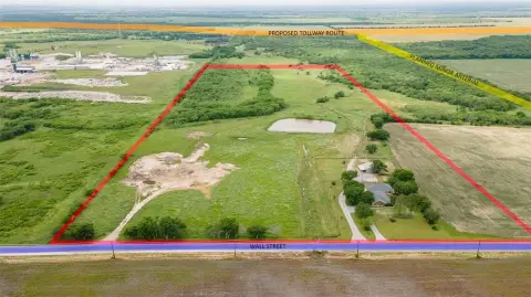
- 30‑acre ag‑exempt tract on a hard corner of FM 121 and JC Maples Rd in the Gunter ETJ
- Flat, rectangular lot with 1,549 ft of frontage on FM 121 and 814 ft on JC Maples Rd
- Public water available and public sewer available
- Property is directly across from the 1,587‑acre master‑planned Bridges at Preston Crossing in Gunter
- Location near major growth areas including Legacy Hills (3,200 acres) and expanding development activity in Gunter
- Future planned updates mentioned include a TXDOT bypass along FM 121 and a Dallas North Tollway expansion
Overview
Situated on a flat, rectangular 30-acre ag-exempt tract, this land parcel offers substantial road exposure along two frontages. The property is configured as a single tract and includes 1,549 feet of frontage along FM 121 and 814 feet along JC Maples Road, providing clear access and development flexibility. It is located within the Gunter ETJ.
The site sits on a hard corner at FM 121 and JC Maples Road, directly across from the Bridges at Preston Crossing master-planned community. The area is actively seeing development activity, with nearby large ranch tracts recently acquired by developers and additional surrounding residential Planned Developments under construction. The location is described as minutes from Sherman, and future transportation improvements are expected to increase regional traffic, including a planned TXDOT bypass along FM 121 and expansion of the Dallas North Tollway.
With its shape, flat terrain, and significant dual-road frontage, the property is well suited for investors and developers evaluating commercial, mixed-use, or other high-density planned development concepts within the Gunter ETJ. Prospective users can also consider the land for future-phased development plans aligned with the ongoing growth in the surrounding corridor.
Property Profile
Location Intelligence
Current Use by Public Records
Commercial land
Map
- City
- Gunter
- County
- Grayson
- State
- Texas
- Longitude
- -96.711696
- Latitude
- 33.440303
Nearby Similar for Sale
FAQs
What type of property is this?
Agricultural land / Farmland - Flat, rectangular 30-acre tract with major road frontage, positioned for commercial, mixed-use, or high-density planning.
Where is this agricultural land / farmland located?
The property is located at JC Maples Road Gunter, TX.
What is the asking price?
The asking price for this property is $8,250,000.
What are key features of this property?
This property features: 30‑acre ag‑exempt tract on a hard corner of FM 121 and JC Maples Rd in the Gunter ETJ; Flat, rectangular lot with 1,549 ft of frontage on FM 121 and 814 ft on JC Maples Rd; Public water available and public sewer available


