Camdenton, MO 65020, Camdenton, MO 65020
- Added:
- Jan 24, 2026
- Days on Market:
- 163
- Last Refresh:
- Jul 6 at 3:06 am
Property Features
General Information
- Property type
- Land
- Property subtype
- Other
- Standard status
- Active
- APN
- 07401800000002032000
- Lot size
- 19.83 Acres
Taxes and HOA fees
- Tax Year
- 2025
- Tax Annual Amount
- 781
Listing agent Sutherland Barr Group License #2020030518 (573) 873-1400
Listing office Better Homes and Gardens Real Estate Lake Realty MO (573) 873-1400
Listing date Jan 24, 2026
Copyright © 2026 Lake of the Ozarks Board of Realtors. All rights reserved. All information provided by the listing agent/broker is deemed reliable but is not guaranteed and should be independently verified.
HighLights
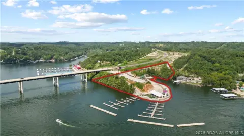
- Approx. 19.83 acres total land with lakefront acreage and water views in Laurie Hollow Cove at Lake of the Ozarks
- 4th tier tract is approx. 5.4 acres (more or less) and does not face the lake; 2nd and 3rd tiers face the cove
- Approx. 6.5 acres (more or less) 2nd tier and approx. 6.7 acres (more or less) 3rd tier with elevated cove and main channel views
- Approx. 500 ft of lakefront, with approx. 300 ft of concrete and rip rap seawall already established
- POA has been set up as Mistwood Moorings POA for the property owner association
- Blacktop is available along the perimeter acreage; Mistwood Airport (24MO) is just up the hill
Overview
The shoreline includes approximately 500 feet of lakefront, with about 300 feet of concrete and rip-rap seawall already in place. The property is situated in Laurie Hollow Cove, within the Lake of the Ozarks area, with Mistwood Airport (24MO) noted as being up the hill. The listing further states that the POA (Property Owner Association) has been set up as Mistwood Moorings POA.
For buyers evaluating a multi-phase land development, this configuration provides direct lake frontage plus elevated viewing areas from the upper tiers. The presence of an established seawall and documented POA setup may help streamline early planning and coordination for a future site development along the cove and main channel views described in the offering.
Current Use by Public Records
Map
- City
- Camdenton
- County
- Camden
- State
- Missouri
- Longitude
- -92.7409
- Latitude
- 37.9635