698 County Road 133, Ovalo, TX 79541
- Added:
- May 7, 2026
- Days on Market:
- 29
- Last Refresh:
- Jun 4 at 5:06 am
Property Features for 698 County Road 133
General Information
- Property type
- Land
- Property subtype
- Other
- Standard status
- Pending
- APN
- 1089750
- Lot size
- 106.15 Acres
Taxes and HOA fees
- Tax Description
- A0096 HOOD COUNTY SCHOOL LAND, ACRES 106.15
- Tax Annual Amount
- 250

Listing agent Clay McCullar License #0635496 (325) 665-4037
Listing office McCullar Properties Group LLC Abilene, TX (325) 665-4037
Listing date May 7, 2026
Copyright © 2026 North Texas Real Estate Information Systems, Inc. All rights reserved. All information provided by the listing agent/broker is deemed reliable but is not guaranteed and should be independently verified.
HighLights
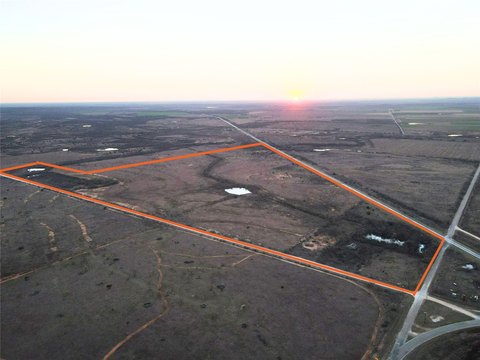
- 106.15+/- acres in Jim Ned ISD, about 4 miles east of Tuscola, Texas
- Wide‑open, unobstructed views with no power lines or wind turbines impacting the landscape
- New entrance with cattle guard and gravel driveway
- Completely fenced land with gently rolling topography
- Includes 2 stock tanks and a water meter available through Steamboat Mountain Water Supply
- Native grasses in good condition with mature live oak trees and smaller mesquite growth present
Overview
Located in Jim Ned ISD and approximately 4 miles east of Tuscola, Texas, the property is described as having wide-open, unobstructed views. The remarks note no power lines or wind turbines impacting the landscape, which helps preserve the feel of the land for recreational use or long-term ownership. With a new access point already in place, the site is positioned for continued development planning.
The combination of fencing, water availability, and rural accessibility makes this land well-suited for a homesite, recreational use, or a long-term land investment strategy. Buyers looking for a straightforward rural parcel with manageable terrain and basic infrastructure elements will likely find it particularly practical.
Current Use by Public Records
Map
- City
- Ovalo
- County
- Taylor
- State
- Texas
- Longitude
- -99.734068
- Latitude
- 32.203902