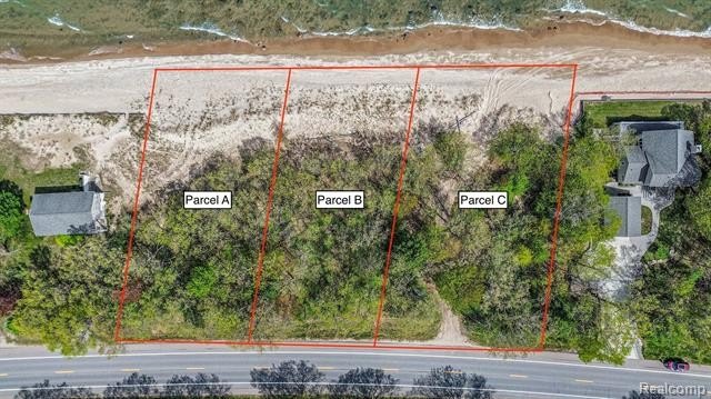
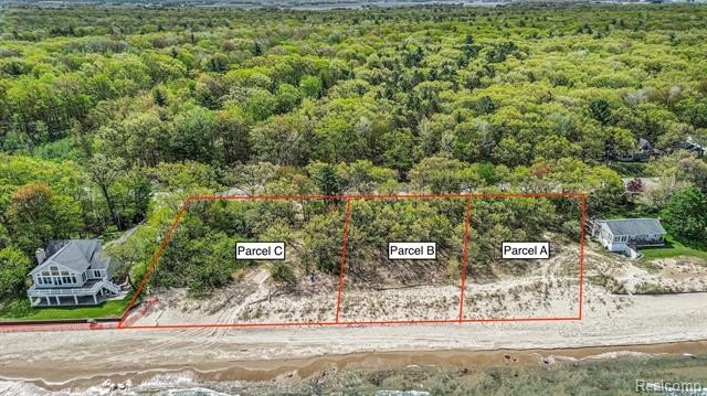
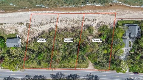
00 Port Austin Rd Parcel C Caseville, MI 48725


LAND - Lake Twp, MI
- Added:
- May 22, 2025
- Days on Market:
- 348
- Last Refresh:
- May 4 at 7:06 am
Property Features for 00 Port Austin Rd Parcel C
General Information
- Property type
- Land
- Property subtype
- Other
- Zoning
- Residential
- Standard status
- Active
- APN
- NewSplit
Taxes and HOA fees
- Tax Description
- Commencing at the South 1/4 Corner of Fractional Section 18, T18N-R11E, Lake Township, Huron County, Michigan; thence N01 degrees 55'51"W 1145.51 feet along the North-South 1/4 Line of said Fractional Section 18; thence along a curve to the right a distance of 199.99 feet, said curve having a Long Chord Bearing and Distance of N73 degrees 15'39"E 199.99 feet and a Radius of 4142.53 feet along the Northerly Line of State Highway M-25 to the Point of Beginning; RUNNING THENCE N01 degrees 52'34"W 192.02 feet; thence N73 degrees 27'06"E 141.34 feet along the Ordinary High Water Mark of Lake Huron; thence S02 degrees 01'57"E 197.37 feet; thence along a curve to the left distance of 140.62 feet, said curve having a Long Chord Bearing and Distance of S75 degrees 36'59"W 140.61 feet and a Radius of 4142.53 feet along said Northerly Right of Way Line of State Highway M-25 to the Point of Beginning. Being a part of the Southeast 1/4 of Fractional Section 18, T18N-R11E, Lake Township, Huron County, Michi
Utilities
- Water source
- Well
Listing agent Genevieve Craig (888) 501-7085
Listing office EXP Realty 928 E 11 Mile Rd, MI (248) 629-0791
Listing date May 22, 2025
MLS# 20250037956
Listing URL
Copyright © 2026 Realcomp Limited II. All rights reserved. All information provided by the listing agent/broker is deemed reliable but is not guaranteed and should be independently verified.
Overview
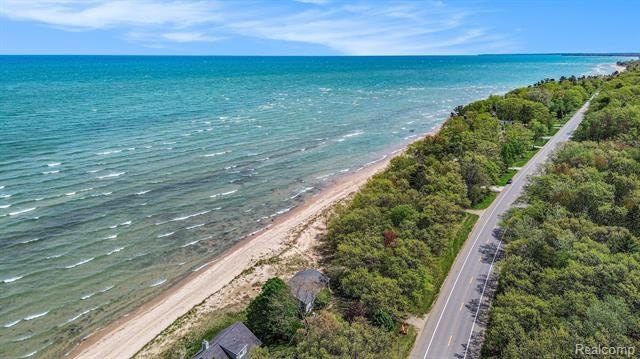
Waterfront Land in Lake Twp
This vacant waterfront lot is located in Lake Twp, MI. It offers 140 feet of frontage, providing ample space for construction. Situated in Caseville, the property allows for enjoying Michigan summers, the Cheeseburger Festival, and the beauty of Lake Huron. The property is zoned for residential use, making it suitable for building a lake house.
Property Profile
Insight Report
Location Intelligence
Current Use by Public Records
Waterfront Land
Map
- City
- Caseville
- County
- Huron
- State
- Michigan
- Longitude
- -83.154785
- Latitude
- 43.986623
Nearby Similar for Sale


FAQs
What type of property is this?
Waterfront Land - Vacant waterfront lot with 140 feet of frontage.
Where is this waterfront land located?
The property is located at 00 Port Austin Rd Parcel C Caseville, MI.
What is the asking price?
The asking price for this property is $750,000.
What are key features of this property?
This property features: Vacant waterfront lot on Lake Huron; 140 feet of water frontage; Opportunity to build a custom lake house


